One of the core pillars of LACO is instrument development in atmospheric remote sensing. Remote sensors observe targets from a far-off vantage point and use indirect information, like reflected sunlight, to infer properties of the target. In the atmosphere, light scattering from clouds, aerosol, land, and ocean enables retrievals of particle size and shape distributions, refractive index, asymmetry, scattering efficiency, and loading. Over a 10+ year space mission, measurements like these give insight on how our climate is adapting to different influences on local, regional, and global scales.
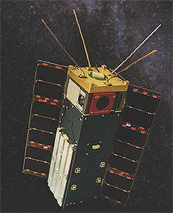
The flagship remote sensing project at LACO is the Hyper-Angular Rainbow Polarimeter (HARP). HARP is a wide field-of-view imaging polarimeter instrument designed for accurate and multi-dimensional measurements of aerosol and cloud properties from space. The HARP CubeSat mission is a NASA ESTO InVest project, with joint collaboration between the Earth and Space Institute at UMBC and the Space Dynamics Laboratory (SDL) at Utah State University. HARP will be the first United States polarimeter in space at launch in 2019.
HARP features:
- 1.5U (10x10x15cm) volume, suitable for CubeSat housing
- Optimized microelectronics and telemetry for small sat hardware constraints
- Custom 2D stripe filter for wavelength and viewing angle selection
- 120 unique viewing angles across a wide 110° radial FOV
- 4 VNIR wavelengths: 440 (10), 550 (10), 670 (10), 870 (40) nm nominal channels and bandwidths
- Simultaneous imaging of three orthogonal linear polarization states
- Adaptable and simple transfer calibration for radiance and polarization
The HARP CubeSat is scheduled to launch from the orbit of the International Space Station (ISS, 400km) no earlier than November 17th, 2018, for a mission lifetime of one year. The HARP CubeSat science mission will be carried out by the UMBC Department of Physics and the mission operations by SDL.

The HARP CubeSat was replicated into the Airborne Hyper-Angular Rainbow Polarimeter (AirHARP), an airborne demonstration of HARP technology, for use on NASA aircraft campaigns. AirHARP participated in the Lake Michigan Ozone Study (LMOS) and the Aerosol Characterization from Polarimeter and LiDAR (ACEPOL) campaigns in 2017 to demonstrate HARP technology and provide practice datasets for the upcoming HARP CubeSat deployment. Click on the image of AirHARP to explore some preliminary datasets and get familiar with HARP science in action.
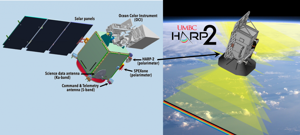
Members of the LACO team, alongside UMBC’s Earth and Space Institute, are currently developing and designing the Hyper-Angular Rainbow Polarimeter 2 (HARP-2), a partnered payload on the upcoming Plankton-Aerosol-Cloud-ocean Ecosystem (PACE) mission in 2021. Improvements to electronics, optics, and sampling schemes increase the observation accuracy of HARP-2 over the HARP CubeSat and AirHARP, although the structure and science of the instrument remains the same. Click on the image of HARP-2 to learn about the PACE mission and HARP-2’s role in removing the atmosphere from ocean measurements.
The LACO group is no stranger to polarized remote sensors. Since 2010, the LACO group designed, built, and deployed polarized imaging instruments to the field to sample and explore cloud and aerosol microphysical properties. The HARP instruments are the product of successful, prior LACO concepts, including the Passive Aerosol and Cloud Suite (PACS) and the Rainbow Polarimetric Imager (RPI), both of which flew on legacy NASA aircraft campaigns.